Weather warnings explained: watch vs warning, yellow, orange and red alerts
What the different weather alert levels mean in the US, UK, Europe and elsewhere, where to get the official alerts for your country, and how to spot a cold snap or storm coming on a forecast map.
When a cold wave, a heat wave or a big storm is on the way, the same question shows up in searches around the world: is there a weather alert where I live, and how serious is it? Every country uses its own words and colours, which makes it confusing when you travel or follow news from abroad. Here is a plain guide.
1. Watch, warning and advisory (United States)
- Advisory: weather that is a nuisance or can be hazardous if you are careless, such as light freezing rain or dense fog.
- Watch: conditions are favourable for dangerous weather. Nothing may be happening yet. Make a plan.
- Warning: dangerous weather is happening or about to happen. Act now.
The US National Weather Service issues these at weather.gov, and phones in the US also receive Wireless Emergency Alerts for the most serious ones.
2. Yellow, orange (amber) and red
Most of Europe, the UK and many other countries use colours instead.
- Yellow: be aware. Weather could cause some disruption.
- Orange or amber: be prepared. Disruption and some danger are likely.
- Red: take action. Dangerous, possibly life-threatening weather is expected.
The UK Met Office sets the colour from two things: how likely the weather is and how big the impact would be, so a yellow warning can mean "very likely, small impact" or "unlikely, big impact". France (Météo-France vigilance), Spain (AEMET), Turkey (MGM), Brazil (INMET) and India (IMD colour codes) all use yellow, orange and red in a similar way. Germany's DWD uses four levels, from a simple weather warning up to extreme severe weather.
3. Where to find the official alerts
| Country or region | Official source |
|---|---|
| United States | National Weather Service (weather.gov) |
| United Kingdom | Met Office |
| Europe (many countries on one map) | Meteoalarm |
| Germany | Deutscher Wetterdienst (DWD) |
| France | Météo-France (vigilance) |
| Spain | AEMET (Meteoalerta) |
| Turkey | MGM (meteorological warnings) |
| Brazil | INMET and Defesa Civil |
| Mexico | Servicio Meteorológico Nacional (SMN) |
| Japan | Japan Meteorological Agency (JMA) |
| South Korea | Korea Meteorological Administration (KMA) |
| India | India Meteorological Department (IMD) |
| Indonesia | BMKG |
| Philippines | PAGASA |
| Vietnam | National Center for Hydro-Meteorological Forecasting (NCHMF) |
| Thailand | Thai Meteorological Department (TMD) |
| Saudi Arabia | National Center for Meteorology (NCM) |
| Egypt | Egyptian Meteorological Authority (EMA) |
Turn on emergency alerts in your phone settings too. In many countries the most serious warnings are pushed to every phone in the area.
4. What to do at each level
- Cold wave or snow: check the forecast low for the next mornings, protect water pipes, plan for slow roads and keep a warm layer and phone charger in the car.
- Heat wave: plan outdoor work for early morning, drink before you are thirsty and check on older neighbours.
- Strong wind or storms: tie down loose things on balconies, stay away from the coast when the sea is rough, and avoid trees and scaffolding.
- Heavy rain: never drive or walk through flood water; it only takes a little to sweep a car away.
Seeing it coming on a map
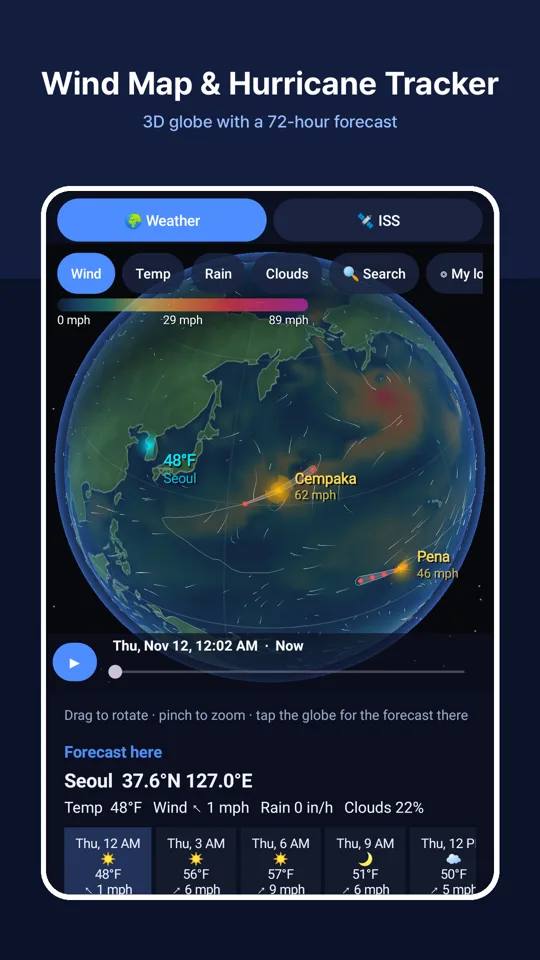
An official warning tells you that something is coming. A forecast map shows you why: the cold air pouring south, the band of heavy rain, the storm turning towards the coast. SpaceUtil has a 3D Earth weather globe with animated wind, temperature, rain and cloud layers and a 72-hour forecast in 3-hour steps, plus tracks and forecast cones for tropical storms and hurricanes. Tap any place for its forecast. The data comes from the global GFS model, refreshed every 6 hours, so it shows large systems well but not a single thunderstorm over your street, and it is not an official warning service. Use it to see the big picture, and follow your national weather service for warnings.
New: the Danger layer colours the places where strong wind, heavy rain, heavy snow, sudden cold or extreme heat may come in the next 72 hours, a card lists the signals for any place you tap, and you can turn on alerts for your location. Your location stays on your phone.